

Why Drone Photography for Highway Corridors Is Changing Infrastructure Surveys
Drone photography for highway corridors is one of the fastest-growing tools in infrastructure planning — and for good reason. Agencies using drones over conventional survey methods are reporting cost savings of 40% or more, while covering ground up to six times faster than traditional manual crews.
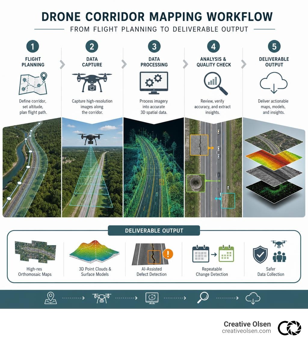
Quick answer: What does drone corridor photography deliver?
Deliverable | What It Means for You |
|---|---|
High-res orthomosaic maps | Accurate to 2.5–5 cm using RTK positioning |
3D point clouds and surface models | Precise elevation data for planning and design |
AI-assisted defect detection | 94% accuracy for pavement, drainage, and structure issues |
Repeatable change detection | Before/after comparisons at scale, on schedule |
Safer data collection | Crews stay off live lanes during data capture |
The pressure on highway teams has never been higher. Budgets are tight, infrastructure is aging, and the cost of missed defects compounds fast. A pavement issue that costs $200 to fix today can escalate to $500,000 or more if left unaddressed.
Drone surveys don't just capture pretty aerial footage. They produce actionable data — orthomosaics, digital elevation models, thermal scans — that feed directly into asset management decisions.
I'm Nate Olsen, Partner and Creative Director at Creative Olsen, and while my background spans commercial photography and aerial production for enterprise B2B clients, the principles behind effective drone photography for highway corridors — precision, repeatability, and purposeful data capture — run through everything we do. Let's break down exactly what a professional corridor drone survey involves and what to look for when hiring for it.
The Evolution of Drone Photography Highway Corridors in Modern Infrastructure

In the past, corridor mapping was a grueling, slow-moving process. Surveyors carrying heavy equipment dodged highway traffic, while manned aircraft flew thousands of feet overhead to capture lower-resolution imagery. Today, in May 2026, the integration of small Unmanned Aircraft Systems (sUAS) has transformed how we visualize, plan, and maintain our transportation networks.
By deploying advanced drone platforms, we can produce high-density 3D photogrammetry, centimeter-accurate orthomosaics, and comprehensive digital twins of complex roadway systems. This evolution is backed by exhaustive research, such as the comprehensive study on Utilizing Unmanned Aircraft Systems for Infrastructure Management, which highlights how UAS provides safer, highly detailed, and unique viewing perspectives compared to ground-based inspections.
As we look across the Midwest — from the rolling terrain of the Jones Creek Wildfire Loess Hills to the expansive highways slicing through the Great Plains — drones have shifted from a novelty to an absolute technical necessity.
Overcoming Traditional Surveying Limitations
Traditional "windshield surveys" — where technicians drive highway shoulders to visually assess pavement conditions — are notoriously subjective and slow. They expose field crews to significant safety hazards from passing vehicles and frequently miss subtle structural degradation.
Furthermore, setting up physical lane closures for manual inspections causes severe traffic disruptions. Drone surveys bypass these bottlenecks entirely. Covering up to 50 miles of pavement per day, a drone corridor survey achieves six times faster coverage than manual crew-based inspections, all while keeping boots completely off the pavement.
Technical Specifications of Drone Photography Highway Corridors
When we talk about professional drone photography highway corridors, we aren't talking about standard consumer-grade snapshots. We are talking about engineering-grade spatial data.
Orthomosaic Accuracy: Professional drone mapping achieves a horizontal and vertical accuracy of 2.5 to 5 cm when utilizing Real-Time Kinematic (RTK) base stations and rover technology.
Ground Sampling Distance (GSD): At typical operating altitudes, drones deliver a GSD of under 3 cm per pixel. This allows engineers to spot hairline cracks, missing guardrail bolts, and joint separations that satellites or manned planes simply cannot resolve.
Specialized Hardware: For demanding environments, enterprise-grade platforms are deployed. For instance, the Matrice 4T Guide: Scouting Highways at High Altitude demonstrates how high-altitude sensors, long-range O3 transmission, and thermal capabilities are critical for scouting long, complex mountain and rural corridors.
Infrastructure Inspection and Asset Management Workflows
A major benefit of utilizing drones for highway corridors is the sheer variety of assets they can monitor in a single flight. Instead of dispatching separate teams to inspect bridges, check signage, and clear drainage ditches, a single aerial mission captures a comprehensive snapshot of the entire right-of-way.
This multi-sensor approach was demonstrated clearly in the regional PROSPER project, which showcased how local transportation agencies can deploy sUAS to inspect bridge decks using RGB, thermal, and multispectral data. These pilot studies conducted across Iowa prove that drones provide an expedited, efficient, and cost-effective means for managing critical infrastructure.
Drones are highly effective at monitoring:
Bridge Decks: Detecting subsurface concrete delamination using thermal sensors.
Pavement Markings: Assessing retroreflectivity and paint wear across miles of lanes.
Drainage Systems: Identifying vegetation blockages, soil erosion, and standing water.
Slope Stability: Spotting minor landslides or rockfall risks along steep highway cuts.
Integrating Aerial Data with CMMS and GIS Platforms
A gorgeous 3D model is useless if it sits forgotten on a hard drive. Modern asset management relies on integrating this data directly into Geographic Information Systems (GIS) and Computerized Maintenance Management Systems (CMMS).
By establishing automated data pipelines, drone-generated point clouds and orthomosaics populate digital twins of the highway network. AI-powered vision algorithms can analyze the imagery, achieve 94% defect detection accuracy, and automatically generate prioritized work orders in the CMMS. This creates a 100% digital twin audit trail — from the initial flight log to the physical repair on the road — ensuring compliance and absolute accountability.
For a complete breakdown of how to plan and execute these advanced aerial captures, see our Drone Videography Aerial Photography Guide 2026.
Safety, Regulations, and Flight Operations
Safety is the absolute foundation of any aerial mission over transportation infrastructure. Operating a drone near active lanes of traffic requires strict adherence to federal and local regulations, meticulous flight planning, and robust risk mitigation strategies.
Metric | Traditional Manual Survey | Drone-Assisted Survey |
|---|---|---|
Traffic Exposure | High (Crews on foot near live lanes) | Zero (Pilots operate from safe stand-off zones) |
Lane Closures Required | Frequent (Causes traffic back-ups) | Extremely Rare (Only for highly specialized tasks) |
Data Collection Speed | Slow (Windshield/walking pace) | 6x Faster (Automated linear flight paths) |
Equipment Footprint | Large (Trucks, cones, arrow boards) | Minimal (Hand-carried drone cases & controllers) |
All commercial drone operations in the United States must be conducted by FAA Part 107 certified remote pilots. When flying over active highways, pilots must navigate the strict rules regarding operations over moving vehicles and human beings. While Beyond Visual Line of Sight (BVLOS) operations are becoming more routine in 2026, they require specific FAA waivers and advanced technical setups, such as onboard ADS-B receivers and remote visual observers stationed at key high points.
Local regulatory landscapes are also shifting rapidly. For example, the Missouri Senate Clears Drone Enforcement Bill, reminding operators that public policy and airspace oversight continue to evolve, requiring professional teams to stay highly informed.
Best Practices for Flight Planning in Drone Photography Highway Corridors
To ensure a successful corridor survey, operators must follow a disciplined, repeatable field workflow:
Terrain Following: Highway corridors often traverse rolling hills or steep valleys. Using terrain-following sensors ensures the drone maintains a constant altitude above the ground, preserving a consistent Ground Sampling Distance (GSD).
Overlap Settings: For clean 3D reconstruction, we recommend a minimum of 75% frontal overlap and 60% side overlap.
KML Import: Pre-planning flights by importing KML/KMZ files directly from GIS software ensures the drone follows the exact centerline of the highway corridor.
Weather & Environmental Management: Wind gusts, dust, and lighting can ruin a flight. For instance, when operating in dusty environments, specialized workflows like those found in the Agras T50 in Dusty Highway Monitoring: A Practical Flight emphasize adjusting flight altitudes (typically 20 to 30 meters AGL) and slowing down to prevent dust backscatter from degrading image quality.
For more on our approach to safety and production standards across the region, check out our guide on Professional Aerial Video Production Services in Nebraska.
Financial Impact and Project ROI
The financial argument for integrating drones into highway planning and maintenance is overwhelming. State Departments of Transportation (DOTs) across the country have documented monetary savings of 40% or more when deploying drones compared to conventional surveying methods.
By identifying pavement cracks, drainage failures, and structural fatigue early through proactive 3D mapping programs, agencies achieve an average 42% reduction in emergency highway downtime. This shift from reactive, emergency repairs to planned, predictive maintenance saves highway authorities an average of $4.1 million annually.
Additionally, drones dramatically accelerate traffic incident management. A pilot study conducted by the Washington State Patrol demonstrated a 75% reduction in road closure times during major traffic incidents by using drones to map collision scenes. Over a nine-month period, this single adjustment saved the public and the state an estimated $4,210,500 in closure-related economic costs.
Case Studies in Corridor Mapping
The power of long-range corridor mapping is proven globally. Consider the remote mapping of the Inuvik–Tuktoyaktuk Highway, Canada’s first all-weather road to the Arctic. The ACUASI remote sensing map successfully mapped 86 miles of remote, harsh terrain, capturing over 60,000 overlapping photos to achieve a stunning 6 cm pixel resolution.
On a local scale, corridor mapping supports crucial environmental and structural projects. For example, during the planning of the Highway 400 wildlife corridor overpass south of Sudbury, Ontario, highly detailed orthomosaic maps allowed engineers to design a seamless crossing that blended into the natural surroundings, significantly reducing wildlife collisions and keeping motorists safe.
Closer to home, whether mapping agricultural corridors near the Mavic over the Flint Hills of Kansas or tracking progress on major Iowa DOT construction projects, drones deliver the precise visual data needed to keep multi-million dollar projects on track and on budget.
Frequently Asked Questions about Highway Drone Surveys
How accurate are drone-generated maps for highway corridors?
With a properly configured RTK (Real-Time Kinematic) GPS network and strategically placed Ground Control Points (GCPs) along the corridor centerline, drone-generated orthomosaics and 3D models can achieve a horizontal and vertical accuracy of 2.5 to 5 centimeters. This is more than sufficient for engineering design, earthwork calculations, and asset monitoring.
Can drones operate over active highway traffic legally?
Yes, but it requires strict adherence to FAA Part 107 regulations. Under the current rules, commercial pilots must avoid flying directly over moving vehicles unless the operation meets specific safety categories or is conducted under an active FAA waiver. Professional operators use offset flight paths, specialized camera angles, and advanced zoom lenses to capture the entire corridor without physically crossing active traffic lanes.
How do drone surveys integrate with existing GIS systems?
Drone data is highly compatible with standard GIS and CAD systems. After processing the raw imagery, professional teams deliver standard, geo-referenced formats including:
TIFF files for high-resolution orthomosaics.
LAS/LAZ files for 3D point clouds.
SHP (Shapefiles) or DXF for vector assets and digitized pavement markings.
DEM/DSM for digital elevation and surface modeling.
Conclusion
When it comes to highway corridor surveying, the old way of working is simply too slow, too expensive, and too dangerous. Transitioning to professional drone photography for highway corridors provides the high-resolution, centimeter-accurate data you need to plan, inspect, and maintain vital infrastructure with absolute confidence.
At Creative Olsen, we serve the Midwest media and corporate industries — including Nebraska, Kansas, Iowa, Missouri, and South Dakota. We combine cinematic, results-driven visuals with a seamless strategy-to-delivery process that aligns perfectly with your agency's goals. Whether you are looking to map a major state highway, inspect critical bridge infrastructure, or document a high-profile construction project, we deliver the precision data and stunning imagery you need.
Ready to elevate your next infrastructure project? Explore our Drone Videography & Aerial Photography Services and let's discuss how we can support your team.


